Jonathan Morris,South Westand
Bee Tucker,South West broadcast meteorologist
 Met Office
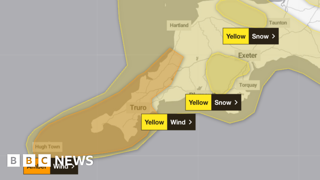
Amber and yellow weather warnings have been issued across the South West with Storm Goretti set to bring snow and winds of up to 100mph (160km/h)
The storm is expected to rapidly develop as it approaches the region by 12:00 GMT.
It has led to an amber wind warning from 16:00 to 23:00 across parts of Cornwall and the Isles of Scilly, as forecasters warn of 80 to 100mph (129 to 160km/h) gusts in “exposed places”, bringing the risk of falling debris and potential danger to life.
There is a further yellow warning for wind for Devon and Cornwall from 15:00 to 06:00 on Friday, while yellow weather warnings for snow, ice and rain are also in force for Devon from 20:00 Thursday to 09:00 Friday.
Goretti, which is currently developing rapidly in the Atlantic, is likely to undergo “explosive cyclogenesis” – also known as a “weather bomb”, say forecasters.
The term explosive cyclogenesis is used where the central pressure drops by 1 millibar an hour over a 24-hour period.
It generally results in particularly powerful gusts of wind over a period of a few hours.
The stormy weather is set to batter the South West with heavy rain and severe gales.
Winds will reach at least 40mph (64km/h), but forecasters warn this is just the start, as gusts could climb much higher over the next 24 hours.
An amber wind warning in force for Cornwall and the Isles of Scilly is the second most severe alert and signals the potential for serious disruption.
Even after the warning expires, gusts of 50 to 60mph (80 to 96km/h) are expected to continue.
Winds of 50 to 70mph (80 to 112km/h) are likely across the region, with the strongest gusts near exposed coasts and hills.
Drivers and commuters are being urged to take extra care as travel disruption is possible.
Snow is also on the cards for higher ground.
The moors could see 0.8 to 2in (2 to 5cm) overnight, with up to 4in (10cm) in some spots.
Coastal flooding possible
Gill Rylance, from the Maritime and Coastguard Agency in Falmouth, said the safest option was to “stay well away from the coast and batten down the hatches at home”.
“We know some mariners have no choice but to be out at sea, but for everyone else, please stay safe,” she told BBC Radio Cornwall.
“If you are tempted to watch the waves, do it from a safe distance and keep your wits about you.”
Rylance warned anyone heading out should carry a way to call for help.
“If you or anyone else gets into difficulty, dial 999 and ask for the coastguard immediately,” she added.
The agency is also monitoring the risk of coastal flooding. High tides combined with strong onshore winds could push water levels up later, leading to possible coastal overtopping in some areas.


